Real Estates
Imagine stepping into the world of real estate, where every property, every lot, and every community is visually represented in an interactive map. With M-Files Process Maps, this is now reality. Upon entering the system, users are greeted with a swift-loading SVG map, providing a bird's-eye view of various properties. With a simple click, this static overview transforms into a dynamic, interactive experience. Hover over a property, and instantly see its status – is it sold, available, or under construction? The use of vibrant, dynamic colors offers a quick visual cue.
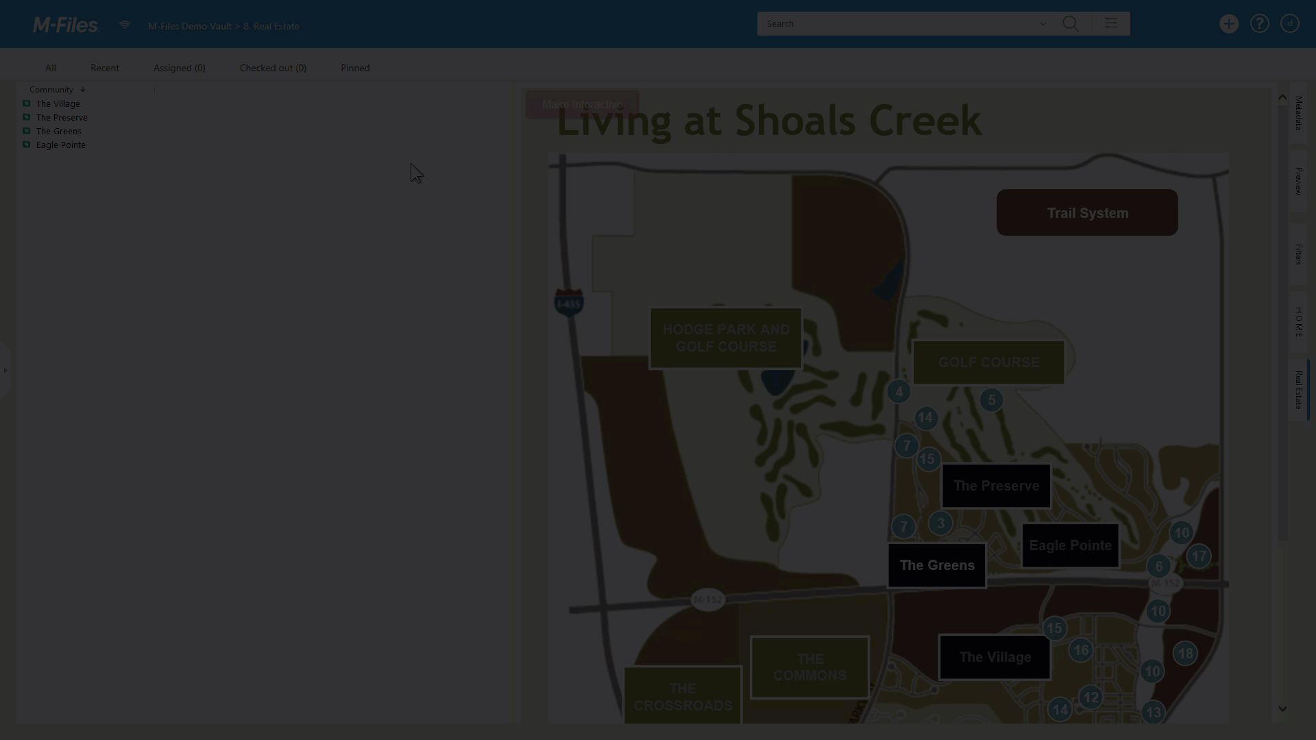
M-Files Process Maps goes beyond just providing a visual representation. It integrates crucial M-Files metadata, ensuring that real estate professionals have all the information they need at their fingertips. Each property on the map is linked to its metadata, offering insights into its history, pricing, and more. This centralized approach ensures that agents, developers, and clients can make informed decisions without having to toggle between different systems.
Customization is at the heart of M-Files Process Maps. Whether it's tailoring icons, integrating external links, or navigating between different views, the add-on is designed to cater to the unique needs of the real estate industry. In a sector where timely information and visual representation are key, M-Files Process Maps offers a custom-fit solution. Dive in, explore, and experience the future of real estate management.
Furthermore, the add-on's adaptability is unmatched. Whether you're a seasoned real estate mogul or a newcomer to the industry, the intuitive interface ensures that you can navigate with ease. The toolbar, customizable icons, and dynamic color changes can be designed with user experience in mind, making complex processes feel straightforward.
One of the standout features is the add-on's ability to seamlessly integrate with other digital tools. For instance, embedding Google Maps directly into the process map isn't just a neat feature; it's a testament to the platform's vision of creating a unified digital ecosystem. This integration ensures that clients can visualize not just the property, but its context within a broader environment, enhancing their understanding and appreciation.
M-Files Process Maps is a powerhouse of features, designed to cater to the intricate needs of the real estate industry. Let's delve deeper into its functionalities and how users can harness them effectively:
- SVG Integration: M-Files Process Maps utilizes Scalable Vector Graphics (SVG) to provide users with swift-loading maps. These SVG files serve as the foundation, ensuring that users don't experience lag or delays, which is crucial when presenting to potential clients.
- Dynamic Interactivity: With a simple activation, the static SVG maps spring to life. Users can hover over properties, access tooltips, and even interact with embedded command icons. This dynamic interactivity ensures that the map is not just a visual aid but a comprehensive data tool.
- Customizable Color Dynamics: Properties can be color-coded based on their status. Whether a lot is sold, available, or under construction, dynamic color changes provide an instant visual cue. This functionality is particularly useful during presentations, allowing clients to quickly grasp the status of various properties.
- Embedded Commands: M-Files Process Maps allows users to embed various commands within the map. For instance, a button can be programmed to open a Google Maps view of the property, providing a real-world perspective. This seamless integration of external tools amplifies the map's utility.
- Meta Data Card Integration: Each property on the map is linked to its meta data card, which contains detailed metadata about the property. This integration ensures that users have a wealth of information at their fingertips, from pricing details to historical data.
- Lazy Loading & Persistent Functionality: These features enhance the user experience by optimizing loading times and ensuring that the map remains consistently accessible as users navigate through different views.
- User-Driven Customization: Beyond the pre-set features, M-Files Process Maps offers extensive customization options. Users can define conditions, change attributes, and even customize the appearance of buttons, ensuring that the map aligns with their branding and aesthetic preferences.
Conclusion on how to use M-Files Process Maps effectively:
- Start with an Overview: When introducing clients or colleaques to a new property or community, begin with an SVG overview. This provides a quick visual introduction without overwhelming them with details.
- Engage with Interactivity: Transition to the interactive mode when delving into specifics. Use the dynamic color changes to highlight property statuses and employ tooltips to provide additional information when needed.
- Harness External Tools: Don't hesitate to integrate external tools via dynamic URL like Google Maps. This provides clients with a comprehensive view, merging the detailed data of M-Files with the real-world context of external platforms.
- Customize for Your Brand: Ensure that the map reflects your brand's identity. Customize icons, colors, and toolbars to align with your company's aesthetic.
- Stay Updated: Regularly update the metadata linked to each property e.g. through M-Files' database connectivity to ensure that clients always have access to the most recent and accurate information.